Pinch of Dirt

Share this post

Another weekend thru-hike

pinchofdirt.substack.com
The Trail Register

Another weekend thru-hike

The Ramapo-Dunderberg Trail

May 2, 2022
10
Share this post

Another weekend thru-hike

pinchofdirt.substack.com

Three years ago I wrote about a weekend thru-hike along the Suffern-Bear Mountain Trail for the New York Times. I chose that trail because it traversed nearly the entire length of Harriman and Bear Mountain State Parks, and so felt like a substantial accomplishment, and because there were easy public transportation options at either end. But there was another trail I could have chosen instead, and now that we’ve hiked it, I think it might be even better than Suffern-Bear Mountain.

I write, of course, of the Ramapo-Dunderberg Trail. Where Suffern-Bear Mountain crosses the two parks on more of a north-south axis, Ramapo-Dunderberg crosses roughly east-west. It begins at the train station in Tuxedo and ends at Jones Point, near the Hudson River. We hiked it backwards, because there’s only one bus per day that returns from Bear Mountain Inn to New York City, and Jones Point isn’t even an established stop—you’d have to wave down the driver and hope they stop to pick you up.

Instead, I asked the driver on the bus to Bear Mountain if he knew the Jones Point flag stop; he did not, but was willing to pull over where I asked him to. I definitely asked him to pull over too far in advance, and we had to walk on the shoulder of 9W longer than I would have liked, but it all worked out because we passed a very conveniently-placed (and conveniently-timed) portapotty.

The Ramapo-Dunderberg Trail is blazed with red on white markers.

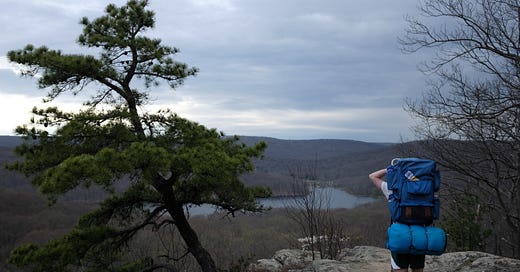
It was immediately clear that 60 miles north of the city, spring was only just arriving. The trees were still mostly bare, only just beginning to bud. While it looked rather barren and desolate, it meant that we had more views than anyone hiking in the summer is likely to have, once the trees fill out.

Dunderberg railway tunnel; the Ramapo-Dunderberg Trail follows part of the route graded for the railway, which was never completed.

As it was, we had pretty extraordinary views of the Hudson not too long after we hit the trail, and eventually of Bear Mountain and Bear Mountain Bridge.

Bear Mountain, with Perkins Tower near the peak, and Bear Mountain Bridge.

I think Ramapo-Dunderberg may be an easier trail than Suffern-Bear Mountain. It was the first to be blazed in Harriman State Park in 1920. According to my 1999 copy of Harriman Trails: A Guide and History, it’s a little over 21 miles long (to Suffern-Bear Mountain’s ~23), although I think it’s been rerouted in at least a few places in the last 20 years, so that could have added or subtracted a few fractions of a mile. More importantly, it seems to follow ridge lines more than the Suffern-Bear Mountain Trail, which goes up and down with unrelenting regularity. It’s also rougher underfoot, if I recall correctly. What makes no sense at all to me is that according to both All Trails and Fastest Known Time, Ramapo-Dunderberg actually has even more elevation gain than Suffern-Bear Mountain. It is possible I’m stronger now than I was three years ago, or perhaps this trail was more enjoyable and so felt easier. Or those websites are wrong! I have no idea.

The brown landscape was frequently broken by these beautiful flowering trees.

Hiking on a weekend with perfect weather, we had lots of company. Some stretches were clearly more popular than others, so we had plenty of trail to ourselves, as well. There’s also something pleasurable in seeing so many people enjoying themselves in the outdoors, as long as they aren’t doing anything annoying that encroaches on your own enjoyment. (In my experience this is easier when you’re expecting crowds than when you’re hoping for solitude.)

Harriman hikes are honestly perfect season openers for us New Yorkers, an opportunity to stretch and strengthen our legs before embarking on potentially more ambitious or novel hikes later in the year. And it’s easy to take for granted but there are some bonkers rock formations to see. Like, glaciers really messed this place up—in a good way.

One thing we didn’t prepare for as well as we might have was the sun. Without tree cover we were exposed nearly all the time—and even in the summer, the Ramapo-Dunderberg Trail frequently crosses exposed rock. I had enough sunscreen for our faces and wore a long-sleeve shirt as much as possible to protect my arms, but my legs and the top of my hands, where I grasp my poles, got roasted.

Water sources are ample this time of the year, although they do start to dry up later in the summer. One stream was flowing enough to stick my feet in while we filtered. So cold it hurt, in the best way.

We camped at Brien Memorial shelter, which is incidentally the first shelter I ever stayed at on my first-ever solo backpacking trip. It’s down in a little hollow, and there’s no view, but I think it’s less popular/crowded because of that. There was still a nice, big flat place for us to pitch our tent for the night when we rolled up around 6pm. It started sprinkling just as we began cooking our dinner (Samurai Ramen) so we finished eating in the shelter. We made two servings in one little pot so the broth was extra concentrated and salty and so, so good.

We got a late-ish start on Sunday, finally breaking camp and hiking out around 9 or 10am. It was nice to know even if we missed the early-evening train from Tuxedo, there was a late-night train several hours later.

The views were not quite as good on the second day as the first, but I love how much exposed rock the trail goes over.

I think I was wearing sunglasses when I took these—or the sun was so bright I couldn’t see how exposed these photos were on my camera.
Trying to capture the striations left by the Laurentide Ice Sheet in the Late Pleistocene. Really thought I was Doing Something but it left a lot to be desired.

We picked up the pace as we neared the end of the hike because neither of us wanted to wait on the train platform for three hours, and had enough time to order takeout Chinese food from the restaurant across from the train station, half of which we inhaled in the 10 minutes before the train pulled up, and the other half we finished hours later (our connecting train from Secaucus was super delayed) back in the apartment.

Hike it yourself (from NYC): Take the Short Line bus to Bear Mountain Inn and ask the driver to let you off at Jones Point (find the trailhead on your maps app and talk to the driver to make sure they stop when you need them to), or walk the ~2 miles from the Tompkins Cove stop on the shoulder of 9W. Brien Memorial Shelter is at mile ~8.5 (not including the road walk), Fingerboard at mile ~12, Bald Rocks at mile ~15, and Tom Jones at mile ~17, so it’s easy to break this up into a 2-3 day trip, depending on your comfort level, or you can do it as a long, intense day hike. Not all of the shelters have water, so fill up when you pass streams. Take the train or the bus back from Tuxedo. The last train was after 9pm when we went, so I think it makes more logistical sense to go from Jones Point to Tuxedo, unless you’re shuttling cars. Happy trails!

Share this post

Another weekend thru-hike

pinchofdirt.substack.com
Comments
TopNewCommunity

No posts

Ready for more?

© 2023 Jessica McKenzie
Privacy ∙ Terms ∙ Collection notice
Start WritingGet the app
Substack is the home for great writing