Itinerary: Park City, Utah
Summer fun in a winter town
This month’s itinerary takes us to Park City, Utah—former mining boom town turned ski resort.
For those new to Pinch of Dirt, this is usually a monthly feature for paid subscribers. Past itineraries have included “overnight kayaking trips in Washington” and “multiday crosscountry ski trips in the northeast,” but requests can be as simple as the best running routes in a city you’re traveling to for work, or good day hikes near where you live (like the Bay Area). If that sounds interesting and helpful, you can subscribe at any time to start requesting outdoorsy itineraries for your own trips, vacations, or staycations.
The earliest evidence of human habitation in Utah dates to 11,000 - 12,000 years ago. The Ute would travel to the Uinta mountain range and the Snyderville Basin near Park City to live and hunt during the warmer months.
The city itself takes its name from an early Mormon settler, Parley P. Pratt, who visited the region in 1848 and built a toll road through it the following year. The settlers who followed called it “Parley’s Park City” which was later shortened to “Park City.”
Although the relationship between indigenous peoples and settlers was not always violent, greater numbers of trappers and settlers in the 19th century depleted game and food resources in the region, causing greater conflict:
In 1853, four customers at Samuel C. Snyder’s sawmill in the Parley’s Park area (now the Snyderville Basin) were fired upon by a party of Ute. Two were killed, while the other two escaped on horses, leaving behind their lumber and beastsof burden. This and other violent incursions resulted in the eventual evacuation of settlers and construction of forts in Henefer, Chalk Creek, Rockport, and Peoa.
The discovery of silver, gold and lead hastened the expulsion of the Ute from the region:
By 1868, around the time silver was discovered in Park City, things had changed. Ute raids ceased and settlers moved out of their forts and back to the Snyderville area. Various treaties and the establishment of reservations limited the lands used by the American Indian peoples and they were eventually forcibly relocated. This left the area open for white settlement and continued development.
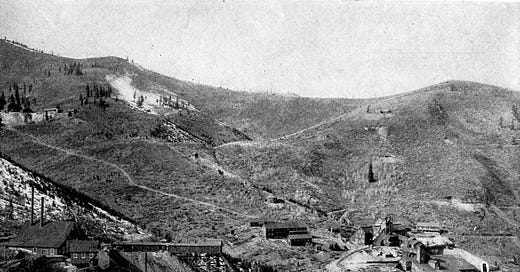
After the silver mining industry collapsed in the mid-20th century (only after 34 miners died in an explosion in 1902), the town rebranded itself as a ski destination. One of the first resorts to open, in 1963—Treasure Mountain ski resort—was built by the United Park City Mines Company.
According to a 1964 New York Times article, the company repurposed old mine shafts as ski lifts, taking tourists “into the heart of the mountain” to an elevator that carried them 1,800 feet up to the top of the mountain. “Youthful skiers,” Jack Goodman reported, “already are referring to it as ‘the tunnel of love.’”
Silver Lake to Bald Mountain (2+ miles)
Take in the wildflowers on your way to summiting Bald Mountain (elevation 9,346 ft) which boasts views of Park City, Deer Valley Resort, Weber Valley, Clayton Peak, Mount Timpanogos, Cascade Mountain, and the Uinta Mountains. There are a couple ways up the mountain from Silver Lake Village, just under three miles from downtown Park City, but for variety, might I suggest a ~4.5 mile loop linking together the Silver Lake and Ontario Canyon trails. (You may even be able to pick up a free chairlift ride down, but you should confirm with Deer Valley before depending on that.)
Bonanza's Abandoned Mine Trail Loop (2.6 miles)
Another good option for seeing wildflowers less than a mile from downtown Park City—throw in the ruins of an abandoned mine for good measure. It’s also reportedly one of the less-trafficked trails near the city. (Although, that’s relative; all these trails are labeled “heavily trafficked” on AllTrails.)
Bloods Lake and Lake Lackawaxen Trail (2.8+ miles)
Hike to two pristine alpine lakes on this popular out-and-back hike not far (~6.5 miles) from downtown Park City. While short, the scenic trail reportedly does get steep and strenuous at points. Fortunately, swimming is allowed, and there’s even a rope swing at Bloods Lake. If you’re tempted to turn around after reaching Bloods Lake (for a 2.8 mile round trip), they say the crowds thin out if you continue on to Lake Lackawaxen (a 4.6 mile round trip).
For a greater challenge: From Bloods Lake you can summit Clayton Peak (elevation 10,689 feet) or 10420 Peak in lieu of (or in addition to) hiking to Lake Lackawaxen.
Hiking not your thing? Park City is a great place to try mountain biking, even for beginners.
Willing to go for a drive? The Homestead Crater, a 65-foot-deep geothermal pool at a near-constant 90 - 96 degree temperature, is just 30 minutes south of Park City. (Reservations required for a 40-minute soak.)
Know anyone else who would find this itinerary helpful and interesting? Feel free to share it with them: